

Reading Time: 3 minutes
Key Takeaways
- Advanced 8µm thermal pixel pitch delivers superior detail compared to standard thermal drones
- 60mm equivalent focal length with 41.2° field of view for precise thermal detection
- Enhanced thermal spatial resolution for detailed asset inspection and precision work
- Dual-camera system combining 48MP wide camera with advanced thermal capabilities
- 45-minute flight time and 15km transmission range for extensive professional operations
Advanced Thermal Imaging for Precision Operations
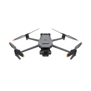
Professional operations across South Africa increasingly require thermal imaging capabilities that deliver precision beyond standard thermal systems. The DJI Mavic 3TA represents advanced thermal drone technology, engineered specifically for applications demanding superior thermal detail and measurement accuracy.
Explore the DJI Mavic 3TA’s complete specifications and capabilities to understand how advanced thermal imaging addresses the most demanding professional requirements. From detailed infrastructure inspection to precision asset monitoring and critical emergency response, the Mavic 3TA’s enhanced thermal performance delivers clarity that standard thermal systems cannot match.
What Makes the Mavic 3TA “Advanced”
The Mavic 3TA distinguishes itself through superior thermal sensor technology designed for precision professional work. The thermal camera features an 8µm pixel pitch compared to the 12µm pitch found in standard thermal drones. This smaller pixel pitch delivers substantially more thermal detail when observing targets from identical distances.
The thermal optics employ a 60mm equivalent focal length with a 41.2° field of view, creating a tighter, more focused thermal image. This optical configuration enhances thermal spatial resolution, revealing temperature variations and component details that broader thermal systems might miss.
Mavic 3T vs Mavic 3TA: Choosing the Right Thermal Solution
Understanding the distinction between the Mavic 3T and Mavic 3TA helps operations select appropriate thermal technology for their requirements.
The Mavic 3T employs a 12µm thermal pixel pitch with 40mm focal length and 61° field of view. This configuration delivers reliable thermal imaging suitable for general applications including routine inspections, search and rescue, and broad-area monitoring. The wider field of view provides efficient coverage for applications where thermal detection matters more than measuring precise temperature variations.
The Mavic 3TA advances thermal performance with an 8µm pixel pitch, 60mm focal length, and 41.2° field of view. This enhanced specification produces sharper, more detailed thermal images essential for precision work. The tighter field of view and superior spatial resolution prove critical for detailed infrastructure inspection, building envelope analysis, and applications requiring accurate identification of smaller thermal anomalies.
For general thermal surveys, security monitoring, or emergency response where broad thermal detection suffices, the Mavic 3T provides excellent capability. For detailed thermal analysis, precise temperature measurement, or inspection of specific components where thermal detail impacts critical decisions, the Mavic 3TA’s advanced performance delivers necessary precision.
Thermal Camera Specifications
The Mavic 3TA features a 640×512 thermal camera optimised for detailed heat signature detection. This resolution, combined with the advanced 8µm pixel pitch, provides exceptional detail for identifying individual heat sources whilst maintaining effective coverage.
The thermal sensor operates across a temperature measurement range from -20°C to 500°C, covering cold-weather operations to high-temperature industrial inspections. Enhanced temperature measurement accuracy supports reliable decision-making across demanding professional applications.
Multiple colour palettes allow operators to optimise thermal display for specific applications. White Hot, Black Hot, and various colour schemes help identify subtle temperature variations relevant to detailed inspection requirements.
Wide Camera Capabilities
The Mavic 3TA incorporates a 48MP wide camera providing detailed visual context alongside thermal data. This dual-camera approach enables comprehensive situational awareness, correlating thermal signatures with visual identification.
The wide camera delivers 4K video at 30fps with a mechanical shutter eliminating rolling shutter distortion. The telephoto camera offers up to 56× hybrid zoom for detailed visual inspection.
Flight Performance and Coverage
With a maximum flight time of 45 minutes, the Mavic 3TA provides substantial coverage capability for detailed inspections of large infrastructure networks or persistent surveillance over extensive operational areas.
The aircraft maintains stable operation in winds up to 12 m/s with reliable thermal data collection. A 15km transmission range supports operations across extensive areas, from large industrial facilities to infrastructure networks.
Professional Applications Requiring Advanced Thermal Precision
Infrastructure Inspection
Electrical infrastructure inspection represents a primary application for the Mavic 3TA’s advanced thermal capabilities. The enhanced thermal detail identifies overheating components, loose connections, and potential failure points with precision supporting preventive maintenance programmes. Solar panel arrays benefit from detecting subtle temperature variations indicating underperforming cells.
Building and Industrial Monitoring
Building envelope analysis requires thermal precision to identify insulation deficiencies and moisture intrusion. Manufacturing facilities employ the system for equipment monitoring where thermal precision indicates developing mechanical problems before failures occur.
Emergency Services
Search and rescue operations gain enhanced capabilities through advanced thermal detection. Fire response teams utilise the enhanced thermal imaging to identify hotspots with precision and ensure complete extinguishment verification.
South African Operating Considerations
Operating conditions across South Africa vary substantially, from coastal humidity to inland temperature extremes. The Mavic 3TA’s operating temperature range from -10°C to 40°C accommodates most South African environments.
Altitude performance remains effective up to 6,000 metres above sea level. Compliance with South African Civil Aviation Authority regulations remains essential for all professional drone operations.
Data Management and Analysis
The Mavic 3TA stores thermal imagery and visual data to internal storage, with microSD card support for extended missions. Data formats remain compatible with professional analysis software for workflow integration.
Real-time data transmission allows immediate decisions based on thermal observations. Enhanced thermal data supports detailed reporting requirements for professional inspections.
Frequently Asked Questions
How does the Mavic 3TA differ from standard thermal drones?
The Mavic 3TA features an advanced thermal sensor with 8µm pixel pitch and 60mm focal length, delivering superior thermal detail compared to standard 12µm thermal systems. This enhanced precision proves essential for detailed inspection work requiring accurate thermal measurement.
What professional applications benefit most from the advanced thermal capabilities?
Infrastructure inspection, building envelope analysis, electrical system monitoring, and detailed asset inspection benefit substantially from the Mavic 3TA’s enhanced thermal precision. Applications requiring accurate thermal measurement and detailed component analysis achieve better results with advanced thermal technology.
Can the thermal camera operate during daytime?
Thermal imaging functions effectively during both day and night operations. Daytime thermal detection proves particularly valuable for infrastructure inspections and equipment monitoring, where temperature variations indicate operational issues requiring precision identification.
What flight time can I expect in real-world operations?
Whilst maximum flight time reaches 45 minutes in optimal conditions, typical operational missions achieve similar performance depending on environmental conditions and flight patterns. Battery management remains straightforward with hot-swappable batteries supporting continuous operations.
What training is required to operate the Mavic 3TA?
Basic flight operations training familiarises operators with aircraft controls and flight planning. Additional thermal imaging training covers advanced data interpretation, temperature measurement techniques, and application-specific operational procedures relevant to precision inspection work.
What maintenance does the Mavic 3TA require?
Regular maintenance includes thermal and visual sensor cleaning, propeller inspection, battery care, and firmware updates. The robust design minimises maintenance requirements whilst ensuring reliable long-term operation across demanding professional applications.
Conclusion
The DJI Mavic 3TA represents advanced thermal imaging technology designed for professional operations requiring precision beyond standard thermal systems. Its superior thermal sensor specifications, enhanced spatial resolution, and detailed measurement capabilities address the demanding requirements of infrastructure inspection, building analysis, and critical operational monitoring.
For operations requiring accurate thermal data, detailed component inspection, or reliable detection of subtle temperature variations, the Mavic 3TA provides proven advanced technology in a practical platform. The system’s precision thermal capabilities make it the appropriate choice for professional applications where thermal detail directly impacts operational outcomes.
Transform your professional operations with advanced thermal imaging technology designed for precision work. Contact Afri Air’s drone specialists for expert guidance on implementing advanced thermal imaging solutions tailored to your specific operational requirements.


